
GT-Loc: Bringing Time and Place Together in Images
Selected as an Oral Presentation at ICCV 2025, GT-Loc is a research effort from David G. Shatwell, Ishan Rajendrakumar Dave, Sirnam Swetha, and Mubarak Shah, affiliated with the Center for Research in Computer Vision and Adobe. Read the paper abstract, grab the full paper PDF, or explore the project code.
Get to know the authors: David G. Shatwell, Ishan Rajendrakumar Dave, Sirnam Swetha, and Mubarak Shah.
Overview
GT-Loc is a geo-temporal retrieval model built to solve two complementary tasks:
- Time Prediction & Geo-Localization: For a query image, GT-Loc encodes the visual content and matches it against two distinct galleries — one of timestamp embeddings and one of GPS-location embeddings. The closest matches yield an estimated capture time (such as a particular date and hour) along with an estimated geographic coordinate.
- Geo-Time Composed Image Retrieval: GT-Loc works in the opposite direction too. You provide a target time and place, each encoded into its own embedding; the two are fused into one query that searches an image gallery and returns the image whose embedding best fits the combined time-and-location request.
Abstract
Timestamp prediction aims to infer when an image was captured using only visual cues, supporting uses such as metadata correction, retrieval, and digital forensics. In outdoor scenes, hourly estimates rely on signals such as brightness, hue, and shadow direction, while seasonal changes and weather help pin down the date. Because these visual cues depend strongly on geographic context, timestamp prediction is tightly coupled with geo-localization. To handle this interdependence, we present GT-Loc, a new retrieval-based approach that jointly predicts an image's capture time (hour and month) and its geo-location (GPS coordinates). Dedicated encoders for images, time, and location align their embeddings inside a shared high-dimensional feature space. Since time is cyclical, instead of standard contrastive learning with hard positives and negatives, we introduce a temporal metric-learning objective that provides soft targets by modeling pairwise time differences across a cyclical toroidal surface. New benchmarks demonstrate that our joint optimization beats earlier time prediction methods, including those supplied with ground-truth geo-location at inference time. Our method also delivers competitive results on standard geo-localization tasks, and the unified embedding space enables compositional and text-based image retrieval.
Method
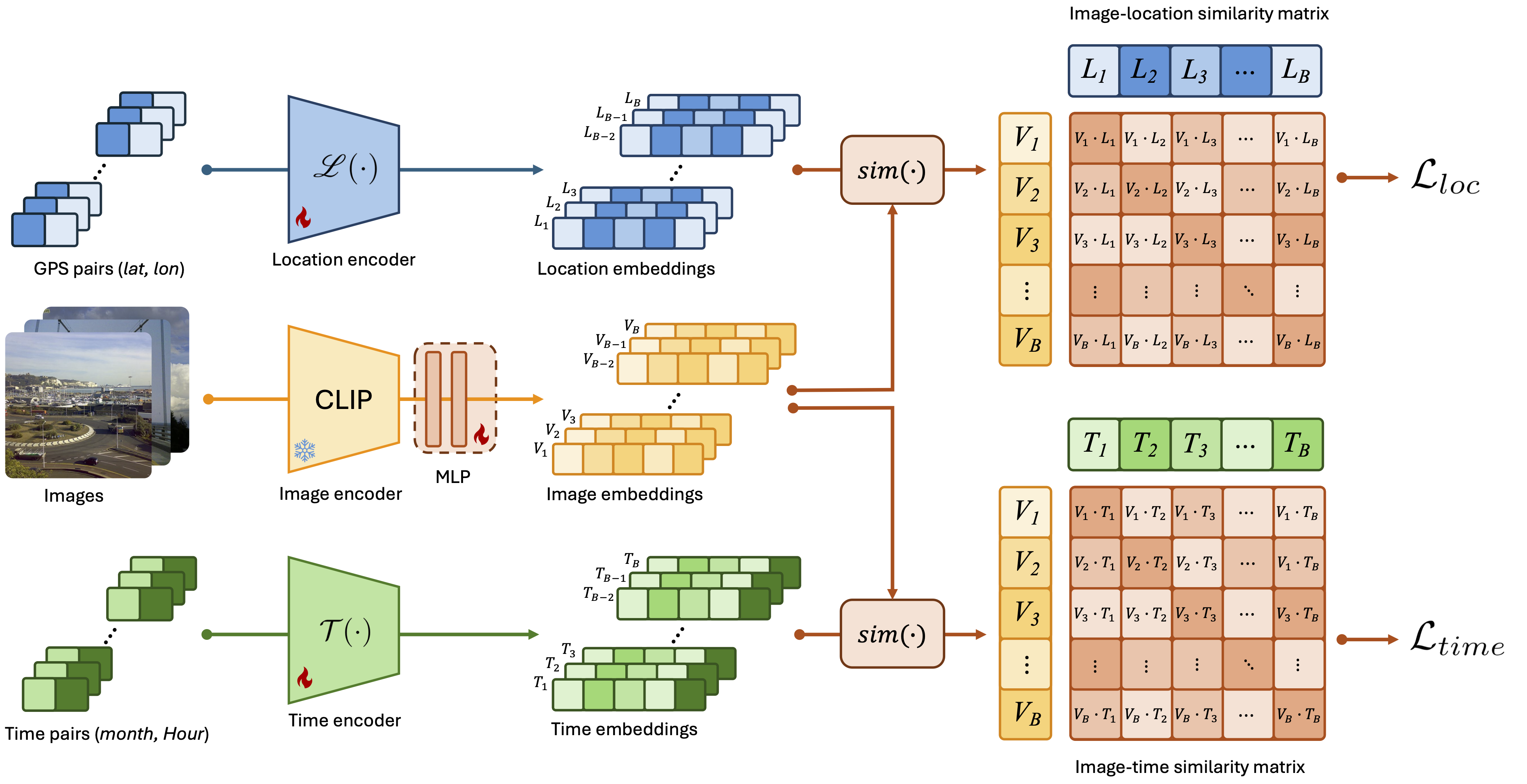
GT-Loc centers on three parallel encoders that map each input into one shared feature space: one for images, one for timestamps, and one for GPS coordinates. At training time, triplets consisting of an image, its true capture time, and its true location are encoded and aligned via two complementary retrieval losses: a new temporal metric learning (TML) loss that softly models cyclic time differences (hour and month) on a toroidal surface, and a geo-localization loss that pulls matching images and coordinates together. Optimizing both objectives jointly produces an embedding space in which any modality can retrieve the others: at test time an image can look up its best-matching time and place, or a chosen time and location can be fused into a combined query to fetch the most relevant image.
Temporal Metric Learning
The model first computes cosine similarities between image embeddings and their paired time embeddings, then applies a cross-entropy loss that pushes these similarities to match a precomputed target distance matrix encoding true cyclic time intervals. This ties embedding similarities to actual temporal distances within the supervision signal.
Cyclic Distance
Every time unit is mapped onto a 2D cyclic surface (a torus) so that true separations follow the shortest wrap-around path. Straight-line (L2) distances on this plane cut across the cycle and thus overestimate real time differences, while the toroidal distance measures wrap-around intervals correctly.
Qualitative Results
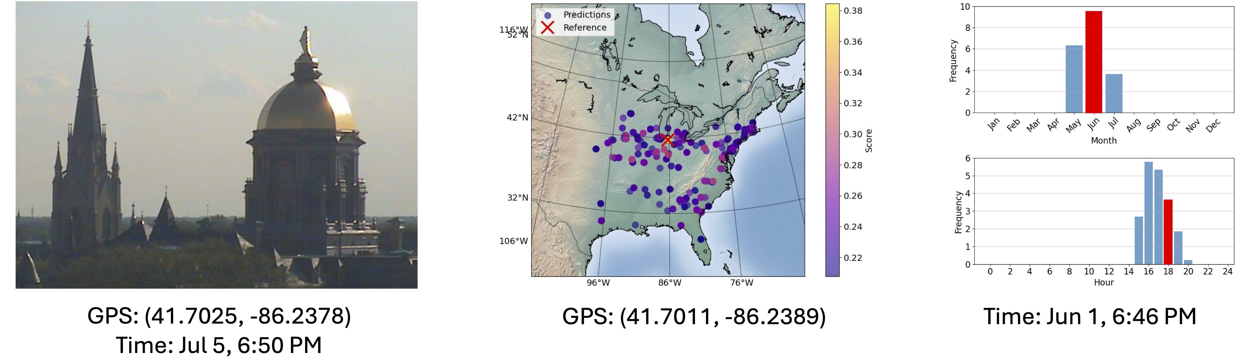
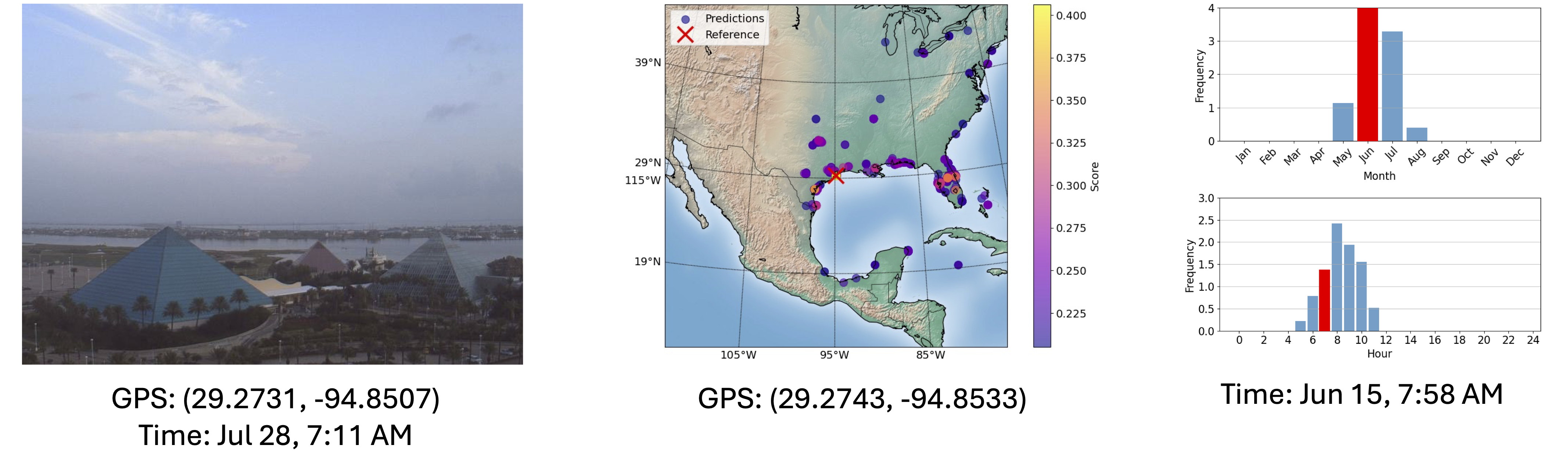
GT-Loc predictions on the SkyFinder test set, with the top-1 predicted location and time displayed beneath the distributions.
Quantitative Results
Time-of-Capture Prediction
Zero-shot time prediction on cameras not seen during training in the SkyFinder dataset. Rows marked with * denote methods we reproduce, following the protocols set out by prior work.
Geo-Localization
Zero-shot geo-localization on the Im2GPS3k and GWS15k datasets, reported as the share of samples correctly predicted within distance thresholds of a 1 km radius.
Image Retrieval
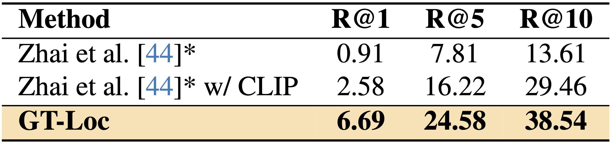
Zero-shot image retrieval (T+L→I) on cameras unseen in the SkyFinder dataset. Given a query location and time, we retrieve the top-k candidate images from a gallery and report the recall metric.
BibTeX
@InProceedings{Shatwell_2025_ICCV, author = {Shatwell, David G. and Dave, Ishan Rajendrakumar and Swetha, Sirnam and Shah, Mubarak}, title = {GT-Loc: Unifying When and Where in Images Through a Joint Embedding Space}, booktitle = {Proceedings of the IEEE/CVF International Conference on Computer Vision (ICCV)}, month = {October}, year = {2025}, pages = {1-11} }
This site is adapted from Nerfies.
GT-Loc shows how a single shared embedding space can connect images, timestamps, and GPS coordinates, so that any one of them can be used to retrieve the others. The same design supports both predicting an image's capture time and location and searching a gallery from a chosen time and place. Explore the paper, code, and results above to see how the approach performs on SkyFinder, Im2GPS3k, and GWS15k.